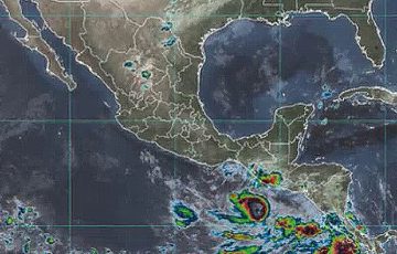
The Ministry of Environment and Natural Resources (MARN) expects the forecasts of the National Hurricane Center (NHC) of the United States, which anticipate that the advance of a cold front and a high pressure will push the climatic adversity towards the ocean, avoiding greater damages in the countries of the region.
The forecast assures that there will be intense rains, increase of winds and decrease in temperatures, although in the last hours the thermometer was above 30 degrees in most of the Salvadoran regions.
While the depression remains almost stationary with a translation movement of four kilometers per hour and stable winds of 55 kilometers, the Civil Protection authorities are rushing the preparation of more than 100 shelters to respond to emergencies.
This Monday there are no classes in the entire Salvadoran educational system as a precaution for the effects of the storm.
The US National Hurricane Center (NHC) indicates that tropical depression 19-E could evolve into a tropical storm.
According to the NHC, the tropical depression is expected to move towards the coast of El Salvador starting Monday, October 30, so its influence will be more direct and rainfall will increase mainly in the coastal area and the volcanic mountain range.
MARN is also monitoring another low pressure system in the Caribbean, which will bring additional humidity to the environment.
The entity notified that in the next few days the Salvadoran coasts will expect high waves due to the spring tides expected from October 28th to the 31st, respectively.
jrr/abo/kmg/lb


